ShopDreamUp AI ArtDreamUp

Deviation Actions


![[WIP] Map of the Vilhon Reach, homebrewed version](https://images-wixmp-ed30a86b8c4ca887773594c2.wixmp.com/f/0eed09bc-443a-4780-926d-08531eee9f17/dd97hwo-7584c21f-355b-4812-bbce-722e58d37e49.png/v1/crop/w_184,h_184,x_1,y_0,scl_0.02790415529269,q_70,strp/_wip__map_of_the_vilhon_reach__homebrewed_version_by_kirsikura_dd97hwo-92s-2x.jpg?token=eyJ0eXAiOiJKV1QiLCJhbGciOiJIUzI1NiJ9.eyJzdWIiOiJ1cm46YXBwOjdlMGQxODg5ODIyNjQzNzNhNWYwZDQxNWVhMGQyNmUwIiwiaXNzIjoidXJuOmFwcDo3ZTBkMTg4OTgyMjY0MzczYTVmMGQ0MTVlYTBkMjZlMCIsIm9iaiI6W1t7ImhlaWdodCI6Ijw9NjU5NCIsInBhdGgiOiJcL2ZcLzBlZWQwOWJjLTQ0M2EtNDc4MC05MjZkLTA4NTMxZWVlOWYxN1wvZGQ5N2h3by03NTg0YzIxZi0zNTViLTQ4MTItYmJjZS03MjJlNThkMzdlNDkucG5nIiwid2lkdGgiOiI8PTY3ODUifV1dLCJhdWQiOlsidXJuOnNlcnZpY2U6aW1hZ2Uub3BlcmF0aW9ucyJdfQ.MoqlWGDGW5S62-U6KclFtxto-6hdcyDCuqx4RJ4gSkQ)
![[WIP] Map of the Vilhon Reach, homebrewed version](https://images-wixmp-ed30a86b8c4ca887773594c2.wixmp.com/f/0eed09bc-443a-4780-926d-08531eee9f17/dd97hwo-7584c21f-355b-4812-bbce-722e58d37e49.png/v1/crop/w_92,h_92,x_1,y_0,scl_0.013952077646345,q_70,strp/_wip__map_of_the_vilhon_reach__homebrewed_version_by_kirsikura_dd97hwo-92s.jpg?token=eyJ0eXAiOiJKV1QiLCJhbGciOiJIUzI1NiJ9.eyJzdWIiOiJ1cm46YXBwOjdlMGQxODg5ODIyNjQzNzNhNWYwZDQxNWVhMGQyNmUwIiwiaXNzIjoidXJuOmFwcDo3ZTBkMTg4OTgyMjY0MzczYTVmMGQ0MTVlYTBkMjZlMCIsIm9iaiI6W1t7ImhlaWdodCI6Ijw9NjU5NCIsInBhdGgiOiJcL2ZcLzBlZWQwOWJjLTQ0M2EtNDc4MC05MjZkLTA4NTMxZWVlOWYxN1wvZGQ5N2h3by03NTg0YzIxZi0zNTViLTQ4MTItYmJjZS03MjJlNThkMzdlNDkucG5nIiwid2lkdGgiOiI8PTY3ODUifV1dLCJhdWQiOlsidXJuOnNlcnZpY2U6aW1hZ2Uub3BlcmF0aW9ucyJdfQ.MoqlWGDGW5S62-U6KclFtxto-6hdcyDCuqx4RJ4gSkQ)


adventureairplaneairplanesancientarttradebellevuebellinghamcartographercartographycoreycroatiadenmarkdigitaldrinkingelvesenglandeuropeeverettfantasyfantasyartfantasycharacterfantasycreaturefantasylandscapefaolfrancegodgodshighfantasyirelandjourneylandscapemapmedievalmenmountainsnorthwestnorwayoceanomegapugetpunkredscifiscotlandseattlespainstesteamlocomotivesteampunkgirlsurrealswedenvictorianwarwashingtonwolfwolfgodwolfwolveswolvescartographersguildfaelishitalyvenezianosteampunkvictorianpphiresteampunkfantasy
Description
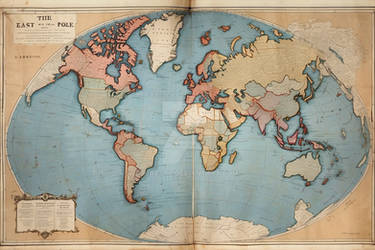
This is a map produced by the Ordenn Ministry of Cartography. It describes in great detail all the rivers, population centers, nations and bodies of water of the World of Vardenn and the surrounding area. It is an Official Map utilized by the Ordenn Imperial Surveyor's Office and as such is considered one of the most accurate maps.
The Histories of Vardenn are long and numerous, but never before has the land and its peoples been so fractured and divided. Each of the traditional powers has been reduced to a mere shadow of its old self, and none of the empires of old remain.
The shattering of the last true Ordic Empire by the Third Sundering War left the north a mess of new kingdoms bearing old grudges. Many have attempted since to create empires of equal standing, none were able to suffer the attrition of time. Though the Tannien Empire, or the Krillen Empire were substantial in their lifespan of several centuries, the Ordic Empire at it's height ruled over both areas.
The collapse of the Lienic Republic left the south a collection of feuding city states and island domains of warlords dressing themselves as "Kings". The prosperity of the Liansk nations had been leeched away by the tremendous cost of the Third Sundering War, allowing any nation who had cause to break away the freedom to do so since the power of the Lienic Republican army was severely lessened. This caused a cascade effect, till soon nothing of the old nation remained. Even centuries later, the devastation of the violence that swept from the tip of Saxik to the horn of Goliet can be felt and seen.
In the place of Empires comes Alliances and Confederations. The most notable being that of the northern powers, specifically between the kingdom of Ordenn, Kottlan, Orge and Norvik. The goal being the protection of their independence against former masters and the ambitions of Kriken Nobles.
Image size
3900x3900px 14.83 MB
© 2016 - 2024 SkullSmithy
Comments4
Join the community to add your comment. Already a deviant? Log In
Looks great. I like the weathered texture of the paper and geographic distribution of the countries. However, a few suggestions:
1. Instead of stripes or bars for undiscovered areas, instead use a solid dark color/shading.
2. Instead of using standard font, use a distinctive hand-writing to imitate the old hand-written maps.
3. The longitude and latitude lines conflict with the old weathered look of the map. Is this suppose to be set in a world that is medieval or post-apocalyptic?